
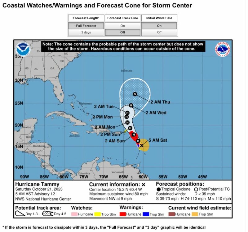
Antigua and Barbuda is at risk of a direct hit from Hurricane Tammy, classified as a category 2 storm.
The latest reports indicate that Hurricane Tammy’s center is located at latitude 15.2 North, longitude 60.4 West, as of 5 am.
The hurricane is moving towards the northwest at a speed of 9 mph (15 km/h), and this general motion is expected to continue through tonight.
On Sunday, a turn towards the north-northwest is predicted to occur, followed by a turn towards the north on Monday.
The Leeward Islands are expected to be impacted by the hurricane, with the center of Tammy moving near or over portions of the islands through early Sunday, then moving north of the northern Leeward Islands by Sunday afternoon.
The hurricane’s maximum sustained winds are near 80 mph (130 km/h) with higher gusts. Tammy’s intensity may fluctuate in the next few days, but it’s expected to remain a hurricane while passing near or over the Leeward Islands.
The hurricane’s hurricane-force winds extend outward up to 25 miles (35 km) from the center, while tropical-storm-force winds extend outward up to 125 miles (205 km).
The estimated minimum central pressure is 991 mb (29.27 inches). Hurricane conditions are expected to begin later this morning in the hurricane warning area and spread northward across the Leeward Islands today and tonight.
Tropical storm conditions are expected within the tropical storm warning areas today and tonight. Hurricane conditions are possible in the hurricane watch areas today and tonight.
The British Virgin Islands will likely experience tropical storm conditions tonight and Sunday, while Martinique may experience tropical storm conditions today.

Tammy is expected to produce storm total rainfall in the following amounts: Leeward Islands – 4 to 8 inches with maximum amounts of 12 inches, Portions of the Windward Islands – 2 to 4 inches with maximum amounts of 6 inches, and British and U.S. Virgin Islands into eastern Puerto Rico – 1 to 2 inches with maximum amounts of 4 inches.
These rains could cause isolated flash and urban flooding along with isolated mudslides in areas of higher terrain.
Storm surge could raise water levels by as much as 1 to 3 feet above normal tide levels near where the center of Tammy moves across the Leeward Islands.
The surge will be accompanied by large and dangerous waves near the coast. Tammy’s swells are likely to cause life-threatening surf and rip current conditions, which will continue to affect portions of the Lesser Antilles in the next few days.
It’s advisable to consult products from your local weather office for more information.

0 Comments