

by Mick the Ram
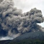
Iceland is gearing itself up for an imminent volcanic eruption on its south-west Reykjanes peninsula, as smoke continues to rise from huge cracks appearing in the ground, after increased earthquake activity since the end of last month.
Scientists say this is due to an underground river of hot magma, roughly 15km (10 miles) in length, moving upwards below the surface of the island, as well as part of of the Atlantic Ocean.
The small town of Grinavik has already been evacuated of its 4,000 residents, leaving everything behind, although with a lull over the past 24 hours, some modest groups have been escorted back to collect pets and essentials.
The authorities are also trying to protect a power plant within what has been declared “the high risk zone” by building a two-mile-long gravel wall, several metres high.
There were fears that if there is an eruption and it flows into the sea, there is a risk of an explosive ash cloud, as the super hot rock comes into contact with the water, similar to the 2010 incident that closed European airspace, causing losses of over a billion euros; but experts remain hopeful that the circumstances surrounding this are very different and will not have such an impact.
Incredibly, the international airport just 15km (10 miles) from the evacuation area remains open and tourists are still arriving.
Experts identify similarities to recent eruptions
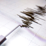
Scientists have been closely studying data from a network of sensors to detect tremors. From these they have recognised that three eruptions in the area in recent years have all followed the same activity patterns to those being felt over the past week or so, with magma breaking through the surface a few days after the volcanic rumblings had died down.
Experts are suggesting that this is a sign that the upward pressure has eased as the magma has spread out horizontally through a tunnel in the bedrock. However, as more molten material pushes up from deep within the Earth – with measurements indicating as much as 75 cubic metres of molten rock per second travelling in the flow – then that pressure is likely to increase and everything points to an eruption in the coming days. They just cannot identify precisely where, or when.

Evacuated residents in distress
Grindavik sits on the south-west tip of Iceland, but unfortunately it also sits directly above the magma stream. There is an impending risk of “fire fountains” and noxious gasses, which has prompted the early evacuation.
Inhabitants were being let back to their homes for a quick five minute dash to pick up valuables or pets, but this had to stop as police were forced to close the road leading into the town, because the queues were beyond the checkpoint on the very edge of the exclusion zone.
With the very real threat of an eruption on their doorstep it is extremely distressing, as many fear they will never see again what they have been forced to leave behind.
Vital power plant
The Svartsengi power plant is just 6km (3.7 miles) from the town and provides heat and electricity for around 35,000 homes in the surrounding area, so it is hoped that by building what is effectively a large dyke, any lava flow that occurs can be diverted away from the vital facility.
Threat of 2010 repeat eases
There had been serious fears that a repeat of the April 2010 Eyjafjallajokull eruption could be about to happen, but several scientists have pointed out that the chaos then was caused by it being a shield volcano and the ensuing smoke cloud was triggered by having a glacier on top of the eruption, which is not the case here.
Therefore, whilst not completely excluding the possibility, there is a belief that the seemingly inevitable eruption will not be as explosive.
Still open for business
Iceland is one of the most volcanic regions on the planet. It sits on the mid-Atlantic ridge, where the tectonic plates of North America and Eurasia are pulling apart by 2cm each year. On average there is an eruption from one of Iceland’s 32 active volcanoes every four or five years, with rivers of lava shaping the stark landscape.
Icelanders have learned to live with this, which probably helps explain why with all this going on, the island life goes on as normal. It is still accepting visitors flying into Keflavik International Airport, just 15km (10 miles) to the north of the evacuated town, and the main highway running from the threatened peninsula to the capital Reykjavik remains open.

0 Comments