
Hurricane Watch in Effect for Barbados

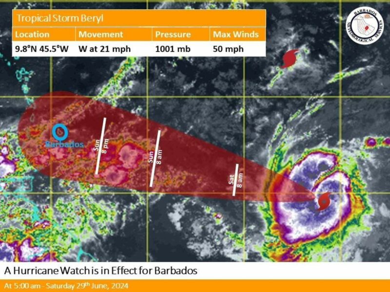
Tropical Storm Beryl is expected to intensify into a hurricane before reaching Barbados late Sunday night, prompting the issuance of a Hurricane Watch for the island.
A Hurricane Watch is declared when sustained winds of 64 knots or greater (74 mph; 119 km/h) associated with a hurricane are predicted to impact Barbados within 48 hours.
As of 5:00 a.m. today, Tropical Storm Beryl has continued to intensify and is located near 9.8N 45.5W, approximately 1570 km (981 miles) east-southeast of Barbados.
It currently has maximum sustained winds of 85 km/h and is moving west at 33 km/h, with a minimum central pressure of 1001 mb.
Based on the current projected path, the center of Beryl is expected to pass about 45 km (26 miles) south of Barbados, with the island likely to experience the effects of the storm as early as late Sunday night (June 30). Residents are warned that strong winds could cause damage to homes and properties, and there is a high risk of flash flooding, particularly in flood-prone areas. Severe thunderstorm activity may also lead to power outages and service disruptions.


About the author
The Editorial Staff refers to all reporters employed by Antigua.news. When an article is not an original creation of Antigua.news—such as when it is based on a press release, other media articles, letters to the editor, or court decisions—one of our staff members is responsible for overseeing its publication.
Read our editorial standards and corrections policy. Spotted an error? Contact the newsroom.
More from Caribbean
View section
St. Kitts DPP Seeks Antigua’s Help in Outstanding Case Involving Former Resort Clerk
By Shermain Bique-Charles

Royal Caribbean in Talks to Buy Half of Sandals in Reported $3 Billion Deal
By Shermain Bique-Charles

Four Killed in Latest US Military Strike on Suspected Drug Vessel in Caribbean
By Shermain Bique-Charles

Browne, Commonwealth Secretary-General Review Final Preparations for CHOGM 2026
By Editorial Staff
Comments
Be the first to comment.
Comments are temporarily unavailable.