
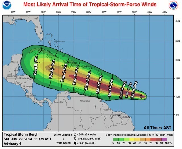
Beryl, the first hurricane of the 2024 season, is gaining strength and is expected to rapidly intensify before hitting the Windward Islands with powerful winds and flooding storm surge.
The National Hurricane Center reported Saturday night that the Category 1 storm, located about 595 miles east of the Windward Islands, was approaching Barbados with maximum sustained winds of 85 mph.
As per latest updates, the tropical storm has intensified into Category 2.
On Saturday, Beryl became the strongest storm ever to form in the tropical Atlantic so far east of the Windward Islands in June. Historically, only two previous hurricanes have been within 100 miles of Barbados before August 1: Emily in 2005 and Elsa in 2021. Only five major hurricanes with winds over 111 mph have been reported in the Atlantic before the first week of July.
According to the National Hurricane Center’s 11 pm forecast, Beryl will become a major hurricane by Sunday evening. It could reach a high-end Category 3 status, with sustained winds of 125 mph and higher gusts, as it arrives in the islands. Wind speeds on the islands are forecast to be up to 30% stronger on the tops and windward sides of hills and mountains.

The center, on Saturday night, issued hurricane warnings for Barbados, St. Lucia, St. Vincent and the Grenadines, and Grenada. Martinique and Tobago are under a tropical storm warning, while Dominica and Tobago have a tropical storm watch.
Residents are urged to prepare for the potential impacts of this rapidly intensifying storm.
Hurricane Beryl threats
Beryl is expected to bring hurricane-force winds, a dangerous storm surge, and heavy rainfall to Barbados and the Windward Islands from Sunday night into Monday. Rainfall totals could reach 3 to 6 inches, potentially causing flooding in vulnerable areas. The storm surge may reach 5 to 7 feet above normal tide levels, accompanied by large, destructive waves.
Southeastern Puerto Rico may receive 1 to 4 inches of rain on Monday night into Tuesday.
0 Comments