
picture by National Hurricane Center
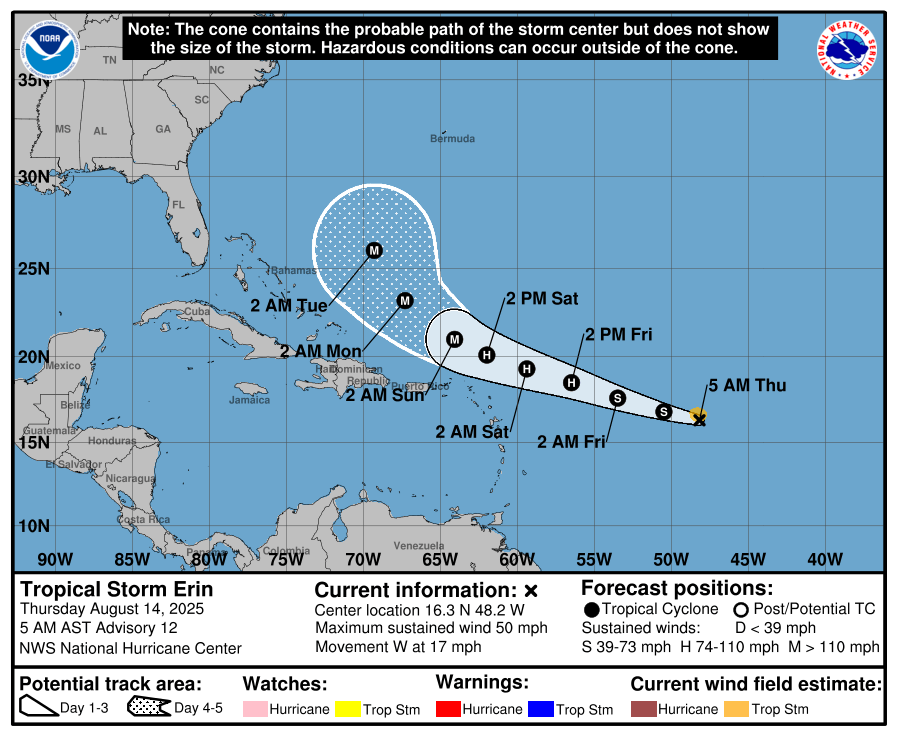
Tropical Storm Erin continues its westward trek across the Atlantic and is expected to strengthen into a hurricane within 24 hours, according to the National Hurricane Center’s latest advisory.
At 5 a.m. AST, the storm’s center was located near latitude 16.3° North and longitude 48.2° West — about 990 miles (1,595 km) east of the northern Leeward Islands.
Erin is moving at 17 mph (28 km/h) toward the west and is forecast to gradually shift toward the west-northwest later tonight, potentially passing near or just north of the northern Leeward Islands this weekend.
")
Maximum sustained winds are currently near 50 mph (85 km/h) with higher gusts. Forecasters expect steady strengthening through today, with a faster rate of intensification on Friday and Saturday. Tropical-storm-force winds extend outward up to 60 miles (95 km) from the center, and the storm’s minimum central pressure is estimated at 1002 mb (29.59 inches).
Residents in the northern Leeward Islands, the Virgin Islands, and Puerto Rico to monitor Erin’s progress closely.
Hazardous swells generated by the storm are expected to reach those islands this weekend, bringing life-threatening surf and rip current conditions.
I never understand these hurricane trackings but I love the rain it’s sending!!!!
Lord protect us in this storm that’s coming!
We are already seeing the effects of the storm.charge your phones. Have batteries on hand. Have enough water ext. Just be prepared
Let’s stay informed by following official reports from the National Hurricane Center and our local Met Office.