

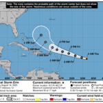
The National Hurricane Center reports that Hurricane Erin, the first hurricane of the 2025 Atlantic season, is packing maximum sustained winds of 75 mph (120 km/h) as it moves west-northwest at 18 mph (30 km/h). As of 11 a.m. AST Friday, Erin was located near latitude 18.2°N, longitude 56.1°W — about 460 miles (740 km) east of the northern Leeward Islands.
A Tropical Storm Watch is in effect for Barbuda, Anguilla, St. Martin, St. Barthelemy, Saba, St. Eustatius, and Sint Maarten, where tropical storm conditions are possible within 48 hours.
Forecasters expect Erin to strengthen rapidly over the next two to three days, potentially becoming a major hurricane this weekend. The system’s center is likely to pass near or just north of the northern Leeward Islands on Saturday.
Heavy rainfall of 2–4 inches (locally up to 6 inches) could trigger flash flooding, landslides, or mudslides in the northern Leeward Islands, Virgin Islands, and Puerto Rico. Large swells are expected to bring dangerous surf and rip currents to the region beginning this weekend.
Residents are urged to monitor updates from their local meteorological services and take preparedness measures.


This is a serious matter. We can’t afford to be complacent. Tropical Storm Erin is strengthening, and even if it doesn’t make a direct hit, the rough seas, high winds, and heavy rainfall can still cause significant damage.
Stay safe all