
 (picture by National Hurricane Center)[/caption]
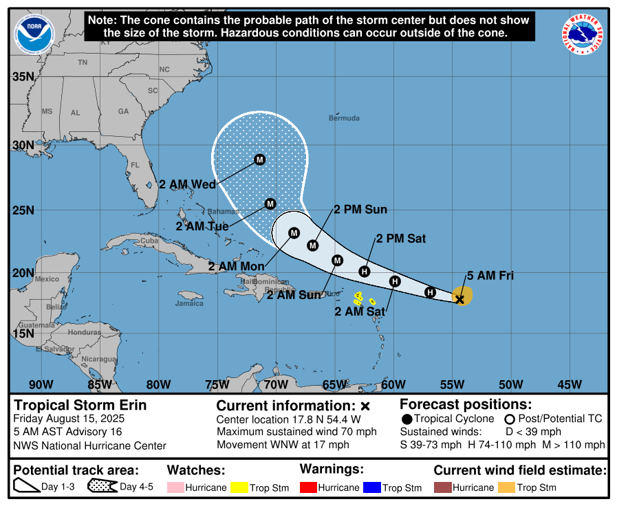
According to the U.S National Hurricane Center, Tropical Storm Erin is slated to become a hurricane today. The storm is currently 570 miles (920 km) east of the Northern Leeward Islands as of 5am, with maximum sustained winds of 70 mph (110 km/h). It is moving West/Northwest at the rate of 17 mph (28 km/h).
Tropical Storm watches are still in effect for Anguilla, Barbuda, St. Martin, St. Barthelemy, Saba, St. Eustatius, and Sint Maarten. According to forecasts, the current motion of the storm is expected to continue into the weekend. On the forecast track, the center of Erin is projected to move near or just north of the northern Leeward Islands over the weekend.
")
It is predicted that Erin could become a major hurricane by this weekend, as tropical-storm-force winds extend outward up to 90 miles (150 km) from the center of the storm. Tropical Storm wind conditions are expected within the Tropical Watch areas by early Saturday.
Heavy rainfall beginning late Friday is expected to be produced by the storm, continuing through the weekend on the northernmost Leeward Islands, the U.S. and British Virgin Islands, as well as southern and eastern Puerto Rico.
According to forecasts, rainfall totals of 2 to 4 inches, with isolated totals of 6 inches, are expected. This rainfall brings risk of flooding, landslides or mudslides.

Guess we are on the safe side now….
Thanks for the update
As if I didn’t see Antigua anywhere in there. Guess that means we won’t be impacted. We welcome the little rain bands though
That’s a relief.