

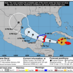
Hurricane Erin has rapidly intensified into a catastrophic Category 5 storm, the strongest classification on the Saffir-Simpson scale, as it moves toward the northern Leeward Islands.
The U.S. National Hurricane Center (NHC) reported that as of 11 a.m. AST, Erin was about 105 miles (170 km) north of Anguilla and 235 miles (375 km) east-northeast of San Juan, Puerto Rico. Maximum sustained winds have increased to 155 mph (250 km/h), The storm’s central pressure is 923 mb (27.26 inches).
Tropical Storm Watches remain in effect for St. Martin, St. Barthelemy, and Sint Maarten, where tropical storm conditions are possible within the next 12 hours. Officials are advising residents throughout the northern Leeward Islands, Virgin Islands, and Puerto Rico to monitor updates closely and prepare for potentially severe weather.
Erin’s outer rainbands are already bringing heavy rainfall, with totals expected between 2 and 4 inches and isolated pockets up to 6 inches, raising the risk of flash flooding, urban flooding, landslides, and mudslides. Hurricane-force winds extend up to 30 miles (45 km) from the center, while tropical-storm-force winds reach up to 140 miles (220 km), mainly to the north.
Swells generated by Erin are affecting the northern Leeward Islands, Virgin Islands, Puerto Rico, Hispaniola, and the Turks and Caicos, and will spread to the Bahamas, Bermuda, and the U.S. east coast early next week, creating life-threatening surf and rip currents.
Authorities are urging the public to secure property, avoid coastal areas, and follow guidance from the Antigua and Barbuda Meteorological Service and other official sources.

Lord lord! Imagine why the Caribbean could’ve been in
Category five. She is up to no good. Go back to where you came from
CATEGORY 5?? I pray for tye country it’s headed to
Staying over open waters is giving it strength….
Wow. Can you believe and do you even understand what we have been speared?
Storm anxiety hits hard. Even safe people can’t stop thinking about those in danger.