
photo by National Hurricane Center in Miami
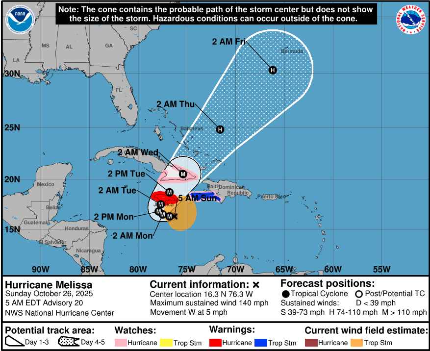
Major Hurricane Melissa is currently located near 16.3°N 76.3°W as of 26/0900 UTC, or approximately 100 nautical miles south-southeast of Kingston, Jamaica, moving west at 4 knots. The estimated minimum central pressure is 944 mb.
Maximum sustained winds are at 120 knots, with gusts reaching 145 knots. Peak sea heights near the center are around 28 feet. Scattered showers and thunderstorms are active within 90 nautical miles of the center.
Additionally, a significant banding feature is developing to the east of the hurricane, with numerous moderate to strong thunderstorms observed from 12°N to 17°N between 70°W and 75°W.
Melissa is expected to move slowly westward, remaining south of Jamaica through Monday night, before making a northward turn and moving inland over Jamaica on Tuesday.
The hurricane is projected to increase its forward speed and traverse eastern Cuba by Tuesday night while maintaining major hurricane strength.
Following this, Melissa will continue northeast, passing over the southern Bahamas on Wednesday and reaching the southeast of Bermuda by late Thursday.
Expected Impacts
- Southern Hispaniola and Jamaica are forecasted to experience very heavy rainfall through at least Wednesday, leading to catastrophic flash flooding and landslides.
- Eastern Cuba is also at risk of heavy rainfall, which may result in life-threatening flash flooding and landslides through Wednesday.
- Swells generated by Melissa are anticipated to impact parts of Hispaniola, Jamaica, and eastern Cuba over the next few days.
Safety Recommendations
- Residents of Jamaica are urged to seek shelter immediately. Damaging winds and heavy rain are expected today and Monday, which will likely cause catastrophic and life-threatening flash flooding, along with numerous landslides before the strongest winds arrive Monday night into Tuesday morning. Extensive infrastructural damage, prolonged power and communication outages, and isolated communities are anticipated. Life-threatening storm surge is also a concern along the southern coast on Monday night and Tuesday morning.
- In Haiti, particularly in the southwestern region, residents face the threat of catastrophic flash flooding and landslides through mid-week, which could lead to extensive infrastructure damage and isolation of communities. While winds are temporarily subsiding on the Tiburon Peninsula, they may increase again across much of western Haiti on Tuesday.
- For the Dominican Republic, heavy rainfall through mid-week poses a risk of catastrophic flash flooding and numerous landslides in the southern regions.
- Residents of eastern Cuba, the Southeast Bahamas, and the Turks and Caicos should closely monitor Hurricane Melissa. There is an escalating risk of significant storm surge, damaging winds, and heavy rainfall by mid-week, with eastern Cuba facing an increased risk of life-threatening flash flooding and landslides. A hurricane watch is currently in effect for portions of eastern Cuba.

Wowwwww. Oh boy. All we can pray for is your safety
This is extremely concerning Melissa’s strength and slow movement near Jamaica could bring catastrophic winds and flooding. With pressure that low and gusts near 145 knots, the potential impact on coastal and mountainous areas is frightening. Praying hard for everyone in Jamaica and the region people need to take this very seriously and prepare now.
Seeing “major hurricane” and “moving inland over Jamaica” in the same sentence gives me chills.
That slow movement is the worst part. It means longer exposure to wind and rain. Flooding could be severe
This is beyond worrying Jamaica could be facing a major disaster if Melissa holds this strength. Everyone needs to stay alert and ready to move.
Heart goes out to Jamaica. We’re watching and praying from across the islands.
Storm bands already stretching far out even areas outside the center are feeling it
The Caribbean has had enough this season. I really hope Melissa weakens before landfall