

A 4.1 magnitude earthquake was recorded early Tuesday morning in waters near Antigua and Barbuda, according to the University of the West Indies Seismic Research Centre.
The automatic earthquake location system detected the tremor at 4:40 a.m. local time on December 16, 2025, at a depth of 10 kilometers.
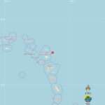
The epicenter was located approximately 233 kilometers east-northeast of St. John’s, Antigua and Barbuda, making it the nearest city to the seismic event.
The earthquake also occurred 244 kilometers northeast of Point-à-Pitre, Guadeloupe, and 282 kilometers east-northeast of Brades, Montserrat.
The coordinates of the earthquake were recorded at latitude 17.59 North and longitude 59.80 West, placing it in the Atlantic Ocean east of the Leeward Islands chain.
The Seismic Research Centre noted that this preliminary location has been automatically calculated by computer algorithms and is subject to potential revisions pending evaluation by SRC analysts.

A 4.1 magnitude might seem small, but shallow quakes like this can definitely be felt by people on nearby islands. Good to see the Seismic Research Centre is monitoring closely.
Interesting how precise the coordinates are, 17.59°N and 59.80°W puts it clearly east of Antigua. Technology really makes earthquake tracking so much faster nowadays.
The frequency in earthquakes lately is beginning to worry me
Just reading the headline i said this to myself