
Tropical Storm Beryl Public Advisory

NWS National Hurricane Center Miami FL AL022024
800 AM AST Sat Jun 29 2024
Corrected distance from Barbados
…BERYL STRENGTHENING…
…EXPECTED TO BECOME A HURRICANE BEFORE IT REACHES THE WINDWARD ISLANDS…
SUMMARY OF 800 AM AST…1200UTC…INFORMATION
———————————————-
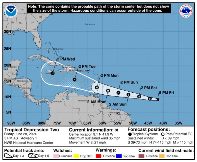
LOCATION…9.8N 46.8W
ABOUT 890 MI…1435 KM ESE OF BARBADOS
MAXIMUM SUSTAINED WINDS…60 MPH…95 KM/H
PRESENT MOVEMENT…W OR 280 DEGREES AT 21 MPH…33 KM/H
MINIMUM CENTRAL PRESSURE…999 MB…29.50 INCHES
WATCHES AND WARNINGS
——————–
CHANGES WITH THIS ADVISORY:
None
SUMMARY OF WATCHES AND WARNINGS IN EFFECT:
A Hurricane Watch is in effect for…
* Barbados
Interests elsewhere in the Lesser Antilles should closely monitor the progress of Beryl. Additional watches and warnings will likely be required for portions of this area later this morning.
For storm information specific to your area, please monitor products issued by your national meteorological service.
DISCUSSION AND OUTLOOK
———————-
At 800 AM AST (1200 UTC), the center of Tropical Storm Beryl was located near latitude 9.8 North, longitude 46.8 West. Beryl is moving toward the west near 21 mph (33 km/h). A relatively quick
westward to west-northwestward motion is expected during the next few days. On the forecast track, the system is expected to move across the Windward Islands late Sunday night and Monday.

Maximum sustained winds have increased to near 60 mph (95 km/h) with higher gusts. Steady to rapid strengthening is expected during the next couple of days, and Beryl is forecast to become a
hurricane tonight or early Sunday with additional strengthening expected after that.
Tropical-storm-force winds extend outward up to 45 miles (75 km) from the center.
The estimated minimum central pressure is 999 mb (29.50 inches).
HAZARDS AFFECTING LAND
———————-
Key messages for Tropical Storm Beryl can be found in the Tropical Cyclone Discussion under AWIPS header MIATCDAT2 and WMO header WTNT42 KNHC.
WIND: Hurricane conditions are possible in the hurricane watch area by Sunday night or Monday morning, with tropical storm conditions possible on Sunday.
STORM SURGE:
A dangerous storm surge will raise water levels by as much as 2 to 4 feet above normal tide levels in areas of onshore flow in the Hurricane Watch area. Near the coast, the surge will be accompanied by large and destructive waves.
RAINFALL:
Tropical Storm Beryl is expected to produce rainfall totals of 3 to 6 inches across Barbados and the Windward Islands. This rainfall may produce localized flooding in vulnerable areas.
For a complete depiction of forecast rainfall and flash flooding associated with Tropical Storm Beryl, please see the National Weather Service Storm Total Rainfall Graphic, available at hurricanes.gov/graphics_at2.shtml?rainqpf and the Flash Flood Risk graphic at hurricanes.gov/graphics_at2.shtml?ero
SURF:
Swells generated by the storm are expected to reach the Windward and southern Leeward Islands by late Sunday. These swells are likely to cause life-threatening surf and rip current conditions. Please consult products from your local weather office.
NEXT ADVISORY
————-
Next complete advisory at 1100 AM AST.
$$
Forecaster Cangialosi
This story was first published by Antigua News on : antigua.news/2024/06/29/tropical-storm-beryl-public-advisory. © 2024 Antigua News. Republication without permission is not allowed.

About the author
The Editorial Staff refers to all reporters employed by Antigua.news. When an article is not an original creation of Antigua.news—such as when it is based on a press release, other media articles, letters to the editor, or court decisions—one of our staff members is responsible for overseeing its publication.
Read our editorial standards and corrections policy. Spotted an error? Contact the newsroom.
More from Caribbean
View section
VIDEO: Doctors at Dominica China Friendship Hospital Stage Protest Outside Medical Facility
Healthcare professionals at the Dominica China Friendship Hospital gather outside the medical facility in an apparent protest, raising concerns over issues yet to be officially confirmed.
By Cory Wayland
St. Kitts DPP Seeks Antigua’s Help in Outstanding Case Involving Former Resort Clerk
By Shermain Bique-Charles

Royal Caribbean in Talks to Buy Half of Sandals in Reported $3 Billion Deal
By Shermain Bique-Charles
Four Killed in Latest US Military Strike on Suspected Drug Vessel in Caribbean
By Shermain Bique-Charles
Comments
Be the first to comment.