
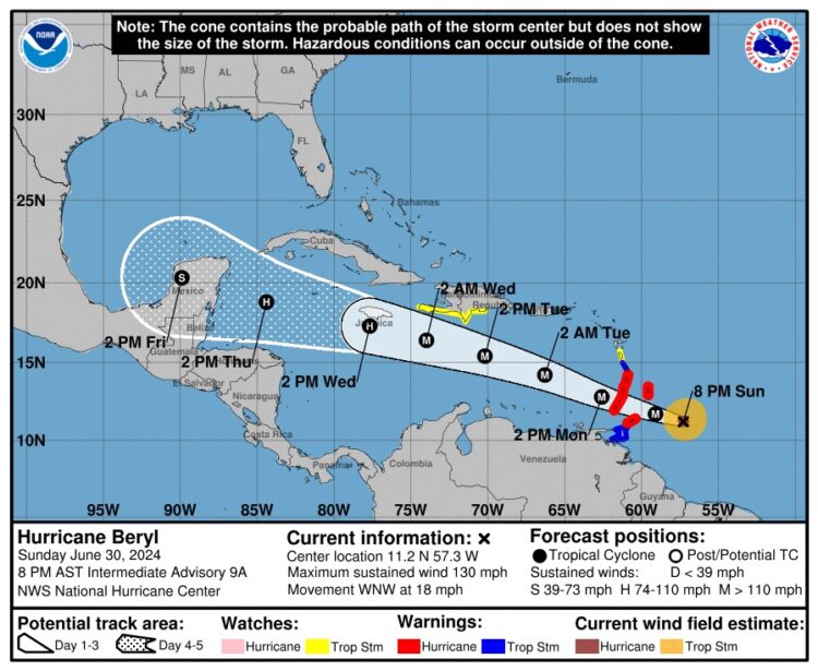
Summary as of 8:00 PM AST (0000 UTC)
- Location: 11.2°N, 57.3°W
- Distance from Barbados: 200 miles (320 km) southeast
- Distance from St. Vincent: 260 miles (480 km) east-southeast
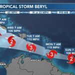
- Maximum Sustained Winds: 130 mph (215 km/h)
- Movement: West-northwest at 18 mph (30 km/h)
- Minimum Central Pressure: 958 mb (28.29 inches)
Watches and Warnings
Changes with This Advisory:
- Tropical Storm Warning issued for Trinidad.
Current Warnings:
- Hurricane Warning: Barbados, St. Lucia, St. Vincent and the Grenadine Islands, Grenada, Tobago.
- Tropical Storm Warning: Martinique, Trinidad.
- Tropical Storm Watch: Dominica, South coast of the Dominican Republic (from Punta Palenque to the Haiti border), South coast of Haiti (from the Dominican Republic border to Anse d’Hainault).
Explanation of Terms:
- Hurricane Warning: Hurricane conditions are expected within the warning area. Immediate action is necessary to protect life and property.
- Tropical Storm Warning: Tropical storm conditions are expected within the warning area within 36 hours.
- Tropical Storm Watch: Tropical storm conditions are possible within the watch area within 48 hours.

Discussion and Outlook
At 8:00 PM AST, Hurricane Beryl is centered at 11.2°N, 57.3°W, moving west-northwest at 18 mph (30 km/h). Beryl is expected to maintain this motion, crossing the Windward Islands Monday morning and progressing across the southeastern and central Caribbean Sea through Wednesday.
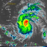
Beryl remains a powerful Category 4 hurricane with maximum sustained winds of 130 mph (215 km/h). Fluctuations in strength are expected, but Beryl is projected to stay extremely dangerous as it approaches the Windward Islands.
Hazards Affecting Land
- Winds: Hurricane conditions will start early Monday morning in the warning areas, potentially causing catastrophic damage, especially in St. Vincent and the Grenadines and Grenada. Wind speeds may be stronger on hills and mountains.
- Storm Surge: Life-threatening storm surges could raise water levels by 6 to 9 feet above normal tides near landfall areas, accompanied by destructive waves.
- Rainfall: Expect 3 to 6 inches of rain across Barbados and the Windward Islands, with localized maxima of 10 inches possible, causing potential flash flooding.
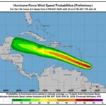
- Surf: Large, life-threatening swells and rip currents are expected across the Windward and southern Leeward Islands, and soon along the southern coasts of Puerto Rico and Hispaniola.
Safety Precautions
- For Those in the Hurricane Warning Area: Complete preparations immediately. Ensure you have a safe place to shelter and enough supplies to last several days.
- For Those in the Tropical Storm Warning and Watch Areas: Monitor local weather updates and be ready to act quickly if conditions worsen.
Next Advisory
The next complete advisory will be issued at 11:00 PM AST. Stay informed through your national meteorological service for storm-specific updates and safety instructions.
(www.nhc.noaa.gov/)
0 Comments