
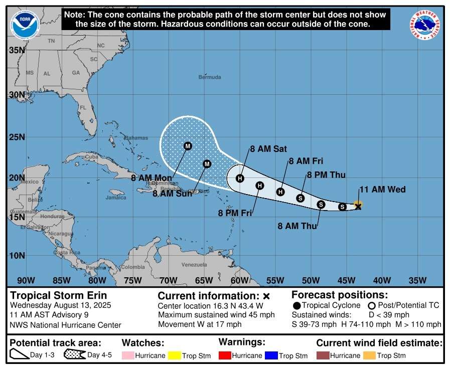
The Antigua and Barbuda Meteorological Service is closely monitoring Tropical Storm Erin as it continues to strengthen in the Atlantic. Forecasters expect the system to become a hurricane by Friday, with a possible track bringing it dangerously close to Antigua and Barbuda and other parts of the northeast Caribbean this weekend.
A few hours ago Erin was located about 1,105 miles east of the Leeward Islands, moving west at roughly 17 mph. The storm’s maximum sustained winds are near 50 mph, with higher gusts, and gradual strengthening is expected over the next two days.
Current projections suggest Erin’s center will likely pass north of the islands, with only a low chance of sustained tropical-storm-force winds. Forecast models place the probability of such winds at around 35 percent for Anguilla and about 10 percent for Antigua.
However, officials warn that any southward shift or continued westward movement could bring the storm’s core uncomfortably close late Friday night or Saturday.

Even without a direct hit, the storm is expected to generate dangerous swells along coastal areas, and additional hazards could develop within the next 24 hours.
Residents in the Leeward Islands and British Virgin Islands are urged to remain vigilant and prepare for possible impacts as the hurricane season continues.
No tropical cyclone alerts, watches, or warnings are currently in effect, though a tropical storm watch could be issued by Thursday. The next official update is scheduled for 5 p.m. tomorrow, or earlier if conditions change.

Please be safe people and have your hurricane plan in place. Buy your cooking gas, canned goods, water, medication ect
Remember to remain safe guys. Ensure all gadgets are charged and what not
Let’s just pray for Gods mercy and protection
Be safe during this time.. be prepared.