
Five tropical disturbances under close watch as hurricane season peaks

By Zaya Williams
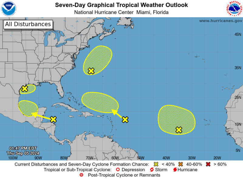
The National Hurricane Center (NHC) is tracking five tropical disturbances across the Atlantic.
While none of these systems currently pose an immediate threat, their potential for development warrants attention.
Each disturbance carries varying degrees of risk and could impact weather conditions in different regions.
It’s crucial to stay informed as these systems evolve, as even low-probability disturbances can escalate rapidly and affect coastal areas.
Here’s a detailed update on their current status and potential impacts:
• Northwest Gulf of Mexico: A broad low-pressure area near the northwestern Gulf is causing showers and thunderstorms. Upper-level winds are expected to become less favourable for development by late Friday and Saturday. Rainfall is anticipated for the northern Gulf Coast, with formation chances at 10% through both 48 hours and 7 days.
• Off the Coast of North Carolina: A low-pressure system several hundred miles off the North Carolina coast is showing increased organization with gale-force winds. It may develop some tropical or subtropical features in the next couple of days but is likely to lose its development potential as it moves into cooler waters by early Saturday. Formation chances are 30% through both 48 hours and 7 days.
• Eastern Tropical Atlantic: An elongated trough of low pressure, located roughly midway between the western coast of Africa and the Lesser Antilles, is producing minimal shower activity. Development is unlikely through the weekend, with chances at 0% through 48 hours and 20% through 7 days.
• Northwestern Caribbean Sea and Southwestern Gulf of Mexico: A tropical wave moving westward through the northwestern Caribbean and into the southwestern Gulf of Mexico is generating disorganized showers and thunderstorms. While significant development is not expected before it reaches Belize and the Yucatan Peninsula early Friday, gradual development could occur later in the weekend into early next week as it continues over the southwestern Gulf. Formation chances are 0% through 48 hours and 20% through 7 days.
• East of the Leeward Islands: A tropical wave located a few hundred miles east of the Leeward Islands is producing limited activity due to strong upper-level winds. Development is unlikely in the near term, but conditions might become more conducive for slow growth by early next week as the system moves into the southwestern Atlantic Ocean. Formation chances are 0% through 48 hours and 10% through 7 days.


About the author
The Editorial Staff refers to all reporters employed by Antigua.news. When an article is not an original creation of Antigua.news—such as when it is based on a press release, other media articles, letters to the editor, or court decisions—one of our staff members is responsible for overseeing its publication.
Read our editorial standards and corrections policy. Spotted an error? Contact the newsroom.
More from Caribbean
View section
St. Kitts DPP Seeks Antigua’s Help in Outstanding Case Involving Former Resort Clerk
By Shermain Bique-Charles

Royal Caribbean in Talks to Buy Half of Sandals in Reported $3 Billion Deal
By Shermain Bique-Charles
Four Killed in Latest US Military Strike on Suspected Drug Vessel in Caribbean
By Shermain Bique-Charles
Browne, Commonwealth Secretary-General Review Final Preparations for CHOGM 2026
By Editorial Staff
Comments (1)
Ana September 11, 2024, 11:10 PM