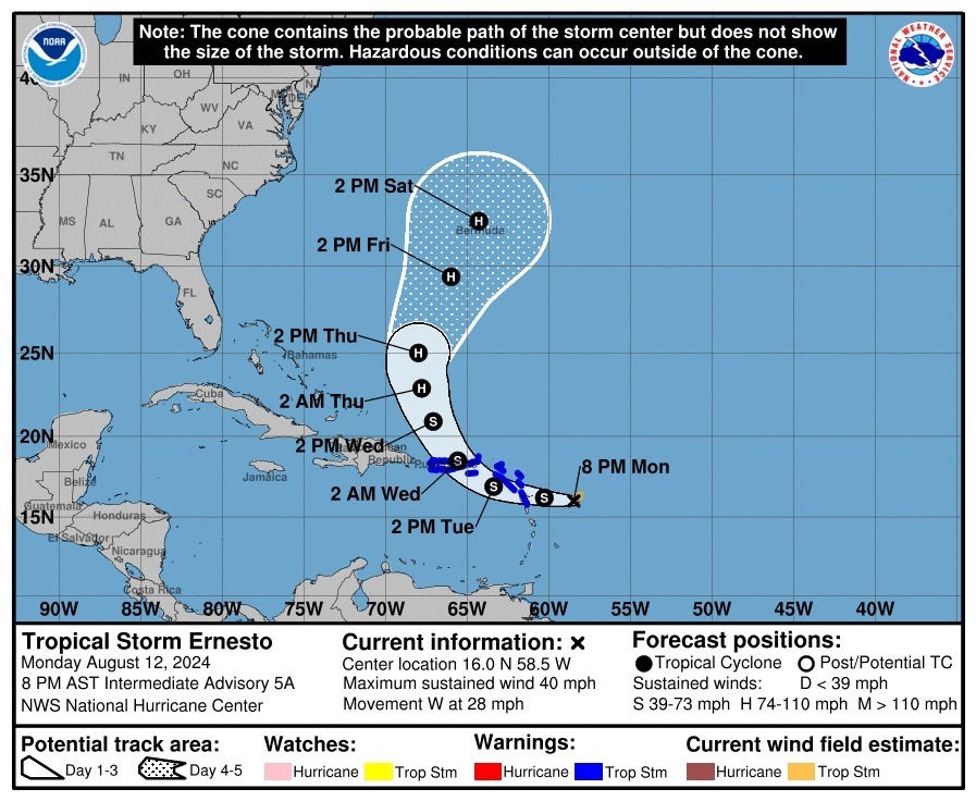
Good news! At 8 pm, Ernesto is back on a westerly track at 28 mph. Also, it remains very disorganised.
BULLETIN
Tropical Storm Ernesto Intermediate Advisory Number 5A
NWS National Hurricane Center Miami FL AL052024
800 PM AST Mon Aug 12 2024
...ERNESTO LIKELY TO BRING STRONG WINDS AND HEAVY RAINS TO
PORTIONS OF THE LEEWARD ISLANDS BEGINNING LATE TONIGHT...
SUMMARY OF 800 PM AST...0000 UTC...INFORMATION
----------------------------------------------
LOCATION...16.0N 58.5W
ABOUT 230 MI...370 KM ESE OF ANTIGUA
ABOUT 530 MI...850 KM ESE OF SAN JUAN PUERTO RICO
MAXIMUM SUSTAINED WINDS...40 MPH...65 KM/H
PRESENT MOVEMENT...W OR 270 DEGREES AT 28 MPH...44 KM/H
MINIMUM CENTRAL PRESSURE...1009 MB...29.80 INCHES
WATCHES AND WARNINGS
--------------------
CHANGES WITH THIS ADVISORY:
None
SUMMARY OF WATCHES AND WARNINGS IN EFFECT:
A Tropical Storm Warning is in effect for...
* St. Kitts, Nevis, Montserrat, Antigua, Barbuda, and Anguilla
* Guadeloupe
* St. Martin and St. Barthelemy
* Sint Maarten
* British Virgin Islands
* U.S. Virgin Islands
* Puerto Rico
* Vieques
* Culebra
A Tropical Storm Warning means that tropical storm conditions are
expected somewhere within the warning area within 36 hours.
Interests elsewhere in the northeastern Caribbean should
monitor the progress of Ernesto.
For storm information specific to your area in the United
States, including possible inland watches and warnings, please
monitor products issued by your local National Weather Service
forecast office. For storm information specific to your area
outside of the United States, please monitor products issued by
your national meteorological service.
DISCUSSION AND OUTLOOK
----------------------
At 800 PM AST (0000 UTC), the center of Tropical Storm Ernesto was
located near latitude 16.0 North, longitude 58.5 West. Ernesto is
moving toward the west near 28 mph (44 km/h). A westward to
west-northwestward motion with some decrease in forward speed is
expected during the next couple of days. On the forecast track,
Ernesto is expected to move across portions of the Leeward Islands
late tonight or Tuesday and near or over the U.S. and British Virgin
Islands and Puerto Rico by Tuesday evening. Ernesto is then
forecast to turn northward over the western Atlantic.
Maximum sustained winds are near 40 mph (65 km/h) with higher
gusts. Gradual strengthening is expected during the next few days.
Tropical-storm-force winds extend outward up to 60 miles (95 km)
from the center.
The estimated minimum central pressure is 1009 mb (29.80 inches).
The Editorial Staff refers to all reporters employed by Antigua.news. When an article is not an original creation of Antigua.news—such as when it is based on a press release, other media articles, letters to the editor, or court decisions—one of our staff members is responsible for overseeing its publication.
By clicking "Accept", you consent to our website's use of cookies to give you the most relevant experience by remembering your preferences and repeat visits.
🔔 Last step
Turn on breaking-news alerts
Choose your sections, tap the button, then tap Allow.






Comments (2)
Faithful national August 12, 2024, 8:30 PM
Andy August 12, 2024, 8:34 PM