

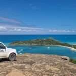
Members of World Travel in 360 with tourism officials in the Bahamas. Photo Credit: Bahamas Minstry of Tourism
Antigua and Barbuda has certainly paved the way for the Google Street View Project in the region, with the Bahamas being the latest to receive comprehensive digital exposure through an extensive Google Street View Coverage Project.
This project was recently completed in Antigua and Barbuda and is led by World Travel in 360, a prominent specialist in 360-degree tourism promotion.
The twin-island nation is the first Caribbean country to benefit from this initiative, thanks to Ambassador Dr. Dario Item, the Ambassador of Antigua and Barbuda to the Kingdom of Spain, the Principality of Liechtenstein, and the Principality of Monaco.
Since the launch of the project, over 3 million people have already used Google Street View to explore Antigua and Barbuda.

Now, World Travel in 360 is collaborating with the Bahamas Ministry of Tourism, Investments & Aviation on a similar project.
This initiative will involve several street view-equipped vehicles with mounted camera systems touring the islands to capture over 2 million geolocated 360-degree images for showcasing the country on Google Maps.
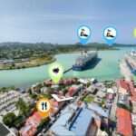
The Bahamas Street View Coverage for Google Maps aims to capture imagery of more than 3,729 miles (6,000 kilometers) of key tourist areas throughout the country’s over 700 islands, including 16 major islands where towns, beaches, and attractions draw millions of incoming travelers.
With this imagery, the Bahamas will join more than 100 countries and territories already featured, either fully or partially, on the Street View function of Google Maps.
This feature is one of the most popular aspects of the application, allowing users to explore different locations worldwide through 360-degree images. It also enables users to easily plan visits, discover attractions, and locate restaurants and hotels using mobile devices, tablets, and computers.
Among the popular tourist areas proposed for photography in the Street View Project are Downtown Nassau, Montagu Beach in Nassau, Port Lucaya Marketplace, Peterson Cay National Park in Grand Bahama, and Marsh Harbour, Green Turtle Cay, and Cherokee Sound in The Abacos.
This Google Street View initiative is a game-changer for Bahamian tourism. By showcasing our islands on Google Maps, we are not only highlighting our natural beauty but also making the Bahamas more accessible than ever.
Potential visitors can virtually explore our diverse offerings at their fingertips, igniting their desire to visit and experience the authentic wonders of our islands firsthand.

Technology at its best, but I just need to ask a question . How do we get to be the leader in this, when Antigua really doesn’t have proper street names or even roads/ street?
We are probably using A.I. technology. You know how we roll…
From what I am understanding the spanish dude brought it here and ANU became the first to launch it. Check it out. The areas they map in ANU looks good so far
I mean all praise to Dr. Item. but lemme ask, how does this benefit us? or anyone in particular? antigua doesnt even have street names so, make it make sense to me. but okay, they are probably fixing things up I guess